|
Arkansas City's Ancient Indian City "Etzanoa"
There has been talk that the "Etzanoa" site could be declared a "National Heritage Site". The possibility of that happening are very great, "IF" the June survey provides all the information that Director Dr. Blakeslee is positive that it will. Initial work has already begun toward that designation becoming a realization. On that note, a visitors center would be the next step for Arkansas City to become a nationally known Historical Destination. This narrator has been circulating this proposed design. Needless to say, it has been well received with the 2 story observation tower and its obvious "Etzanoa" flair? Seeing into the future sometimes comes easy if you close your eyes to today.
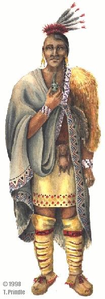
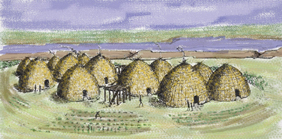
Arkansas City's Ancient Indian City "Etzanoa" For those not familiar with the area. The site starts 1/2 mile East of Arkansas City along the Walnut River and continues East for almost 2 miles. From the South it starts at the Arkansas River and goes North for 6 miles [main settlement] again following the Walnut River. Smaller villages of the same peoples extended along the Walnut, at Winfield, then a larger group at Douglas, then another of the same size at Agusta, Ks. All this for a total of 26 miles. Occupied for 100's of years, beginning somewhere around mid 1400's and discovered by the Spainards in 1595. With the second encounter with the Spaniards in 1601, the ["Main City"] settlement at "Etzanoa" was counted and documented as having a population of 20,000 natives. Because of a river that never went dry with many tributaries and springs, very rich river bottom ground that never was depleted, and thousands of buffalo, consequently the "city" thrived. The river still flows today with some of the richest farm ground in all of Kansas. These people have been attributed as being part of the Wichita Tribe of the 1600's.
It has been confirmed that this past weekend a Wichita State University Archaeology Team was here in Arkansas City to evaluate the entire "Etzanoa" site and its potential as a possible major investigative possibility. Rumor has it that they were overwhelmed with the site. Remarks such as, "This is absolutely unbelievable" were overheard. Also, they were not prepared for the amount of acreage that has been granted for the survey by property owners in AC. The total so far is 1,202 acres that they will be able to survey. Their first reaction to that amount of acreage was that maybe Arkansas City does see the possibilities for a National recognition of their ancient history. Regrettably, some reluctant land owners still view this merely as an attempt to infringe on their rights of land ownership. But, lets look at all the acres that the locals have offered as a sign and a step toward the future recognition. The possibility of putting "Etzanoa" on the map as a recognized "Ancient City" by WSU and the entire world archaeological community are within our grasp. "Finally, Ark City" are this narrators thoughts & hope.
If you agree with the possibilities, it is hoped you "share" this with your friends from afar.
The Anthropology Program at Cowley College, with the Cowley Public Archaeology & History Group, will explore the history of the “first” Ark City at the fourth annual Kansas Archaeology this Saturday. The event runs from 9 a.m. to 3 p.m. in the Earle N. Wright Community Room at Cowley College, and is free and open to the public.
In 1601, Spanish conquistador and explorer Juan de Oñate encountered a great settlement called Etzanoa at the confluence of the Arkansas and Walnut rivers. Based on new translations of the Spanish documents, it appears this town was home to 20,000 people, more than Arkansas City today. This would also make it the second-largest Native American settlement in North American history.
Dr. Donald Blakeslee, professor of anthropology at Wichita State University, is undertaking a major research project in the region, looking for the archaeological remains of this settlement. He will present the day’s keynote address at noon, discussing the research and the history of the region and its people. The public is invited to bring a sack lunch for the noon-time presentation.
Dr. Blakeslee will also conduct artifact identification workshops at 10 a.m. and 2 p.m., for those who are interested in assisting with the local research. Collectors are encouraged to bring their artifacts for possible identification.
Exhibits by Cowley archaeology students on Great Bend archaeology and proto-Wichita culture will be on display all day. There will also be a display on the tools of archaeology. Activities for children include the popular kid’s dig, in which young children can participate in a simulated archaeological excavation, and a pottery puzzle that challenges children to put the artifact back together.
For more information, contact Chris Mayer, Cowley College faculty member and head of the Anthropology Program, at 620-441-5229, or by finding Cowley College Anthropology on Facebook.
This narrator is going to deviate from the planned post of the Medicine Lodge importance to the Etzanoa inhabitants and instead maybe clarify some terminology.
The archaeology tools and technology used for gathering information about a possible prehistoric or historic site buried under the present site surface has come "light years" in just the last 10 / 15 years. As noted below , in at least two [2] posts was information about some of the technology used in todays exploration of ancient sites around the world. The most commonly used being the magnetometer [a cousin is the common metal detector] , also, but of greater significance is " ground penetrating radar", another is drone photography from say 300 /400 ft. altitude, or "Google Earth" which is from several imaging satellites at altitudes from 478 miles down to 250 miles above Ark City. And the latest and greatest is called LIDAR technology, this is based on laser lights and radar combined. LIDAR units usually are mounted for aerial imaging. These LIDAR units have been used to find ancient civilizations that have been covered by vegetation and dense forest for 2,000 years.
Now, for the clarification, this narrator, along with many Etzanoa site planners, historical history buffs, and local land owners or just interested citizens, have on more than one occasion referred to this summers survey as a "Dig". Yes, as stated before that was what had to be done years ago to obtain any information about a subsurface site and is commonly still used today as the word for any exploration of this type. However, the property owners that have very kindly given permission to "survey" their land are expecting and will have pictures taken of their land and like a National Park slogan we will "only leave a foot print".
.
|
|
|
.
In June 1598, Juan de Oñate led a group of Spanish settlers through the Jornada del Muerto, an inhospitable patch of desert that ends just south of the present-day city of Socorro. As the Spaniards emerged from the desert, Piro Indians of the pueblo of Teypana gave the Spaniards food and water. Therefore, the Spaniards renamed this pueblo Socorro, which means “help” or “aid”. Later, the name “Socorro” would be applied to the nearby Piro pueblo of Pilabó.
Great Plains Expedition
In 1601, Oñate undertook a large expedition east to the Great Plains region of central North America. There were 130 Spanish soldiers and twelve Franciscan priests, similar to the expedition of the Spanish conquest of the Aztec Empire, and a retinue of 130 Indian soldiers and servants, and 350 horses and mules. Oñate journeyed across the plains eastward from New Mexico in a renewed search for Quivira, fabled “city of gold.” As had the earlier Coronado Expedition in the 1540s, he encountered Apaches in the “Texas Panhandle” region. He proceeded eastward following the Canadian River into the “Oklahoma” region. Leaving the river behind in a sandy area where his ox carts could not pass, he went cross country, and the land became greener, with more water and groves of Black walnut (Juglans nigra) and Bur oak (Quercus macrocarpa) trees.
Escanjaque People
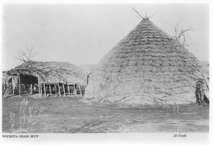
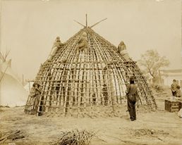
Jusepe probably led Oñate on the same route he had taken on the Umana and Leyba expedition six years earlier. They found an encampment of native people that Oñate called the Escanjaques. He estimated the population at more than 5,000 living in 600 houses. The Escanjaques lived in round houses as large as 90 feet (27 m) in diameter and covered with tanned buffalo hides. They were hunters, according to Oñate, depending upon the buffalo for their subsistence and planting no crops.
The Escanjaques told Oñate that a large settlement of their enemies, the Rayado Indians, was located only about twenty miles away in a region called Etzanoa. Thus, it seems possible that the Escanjaques had gathered together in large numbers either out of fear of the Rayados or to undertake a war against them. They attempted to enlist the assistance of the Spanish and their firearms, alleging that the Rayados were responsible for the deaths of Humana and Leyva a few years before.
The Escanjaques guided Oñate to a large river a few miles away and he became the first European to describe the tallgrass prairie. He spoke of fertile land, much better than that through which he had previously passed, and pastures “so good that in many places the grass was high enough to conceal a horse.” He tasted and found of good flavor a fruit that sounds like the Pawpaw.
Rayados Peoples
Near the river, Oñate, the Spaniards, and their numerous Escanjaque guides saw three or four hundred Rayados on a hill. The Rayados advanced, throwing dirt into the air as a sign that they were ready for war. Oñate quickly indicated that he did not wish to fight and made peace with this group of Rayados, who proved to be friendly and generous. Oñate liked the Rayados more than he did the Escanjaques. They were “united, peaceful, and settled.” They showed deference to their chief, named Caratax, whom Oñate detained as a guide and hostage, although “treating him well.”
Caratax led Oñate and the Escanjaques across the river to a settlement on the eastern bank, one or two miles from the river. The settlement was deserted, the inhabitants having fled. It contained “about twelve hundred houses, all established along the bank of another good-sized river which flowed into the large one [the Arkansas]…. the settlement of the Rayados seemed typical of those seen by Coronado in Quivira sixty years before. The homesteads were dispersed; the houses round, thatched with grass, large enough to sleep ten persons each, and surrounded by large granaries to store the corn, beans, and squash they grew in their fields.” With difficulty Oñate restrained the Escanjaques from looting the town and sent them home.
The next day Oñate expedition proceeded onward for another eight miles through heavily populated territory, although without seeing many Rayados. At this point, the Spaniard’s courage deserted them. There were obviously many Rayados nearby and the Spaniards were warned that the Rayados were assembling an army. Discretion seemed the better part of valor. Oñate estimated that three hundred Spanish soldiers would be needed to confront the Rayados, and he turned his soldiers around to return to New Mexico.
Contemporary Studies
The path of Oñate’s expedition and the identity of the Escanjaques and the Rayados are much debated. Most authorities believe his route led down the Canadian River from Texas to Oklahoma, cross-country to the Salt Fork, where he found the Escanjaque encampment, and then to the Arkansas River and its tributary, the Walnut River at Arkansas City, Kansas where the Rayado settlement was located. A minority view would be that the Escanjaque encampment was on the Ninnescah River and the Rayado village was on the site of present day Wichita, Kansas. Archaeological evidence favors the Walnut River site.
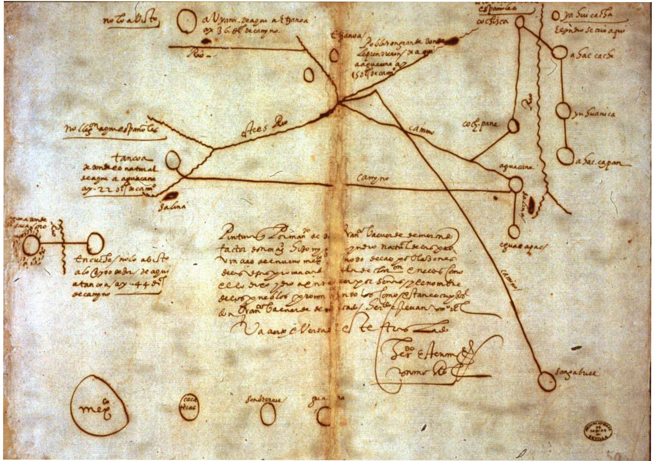
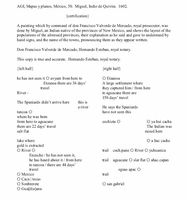
Authorities have speculated that the Escanjaques were Apache, Tonkawa, Jumano, Quapaw, Kaw, or other tribes. Most likely they were Caddoan and spoke a Wichita dialect. We can be virtually certain that the Rayados were Caddoan Wichitas. Their grass houses, dispersed mode of settlement, a chief named Catarax, a Wichita title, the description of their granaries, and their location all are in accord with Coronado’s earlier description of the Quivirans. However, they were probably not the same people Coronado had met. Coronado found Quivira 120 miles north of Oñate’s Rayados . The Rayados spoke of large settlements called Tancoa—perhaps the real name of Quivira—in that area to the north. Thus, the Rayados were related culturally and linguistically to the Quivirans but not in the same political entity. The Wichita at this time were not unified, but rather a large number of related tribes scattered over most of Kansasand Oklahoma. That the Rayados and Escanjaques may have spoken the same language, but were nevertheless enemies is not implausible. Oñate’s 1605 “signature grafitti” on Inscription Rock, in El Morro National Monument.
|
|

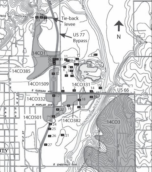 This is a map of the sites that have been investigated.