The Conley and Eddy Family Migration to Kansas onto Indian Land in the 1860's
The history will contrast the Potawatomi
Indians and the Osage Indians up to the time when lands were ceded and the
relationship between these events and my family coming to
Kansas.
Figure 1 and 2 are from the 1855 History of Kansas and describes the
Osage land as a strip 50 miles wide and 165 miles long. The Potawatomi land in Kansas was an area 30 miles square and was
ceded very soon after 1855. My fathers
family, the Conleys, migrated to Osage Trust lands and my mothers family the
Eddys migrated to Potawatomi reservation land (figures 3 through 7). The names of the owners were Wahunsonacock
which is a Powhatan Indian name. The reservation was Potawatomi. The paper is the comparison between the Potawatomi
Indians and the Osage Indians culture. The paper refers to contemporary political
boundaries rather than state the obvious that they were future Kansas counties or
states at the time of Indian migration.
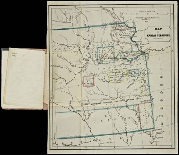
Figure 1: Map showing
Indian
Land
in 1855, the period just prior to
when my ancestors came to
Kansas
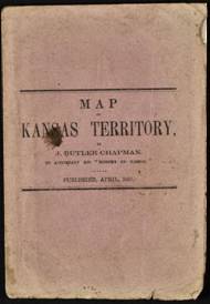 figure 2 describes the map
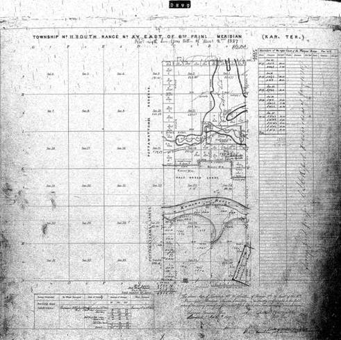
Figure 3: section 31 Land sold by Joseph Negahnquet
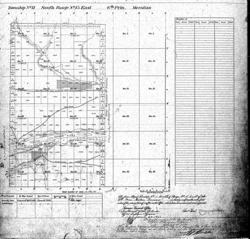
Figure 4: The
Topeka
land a little later.
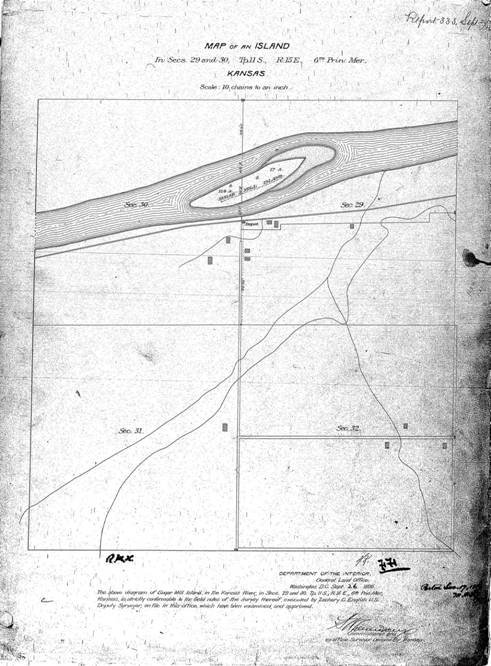
Figure 5: This shows the house on the NE corner of Section
31.
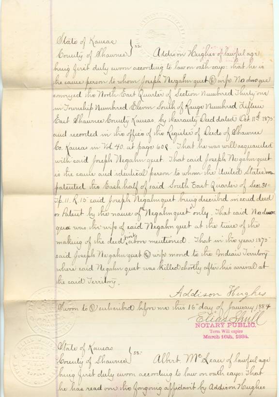
Figure 6: Patent for the
Topeka
land
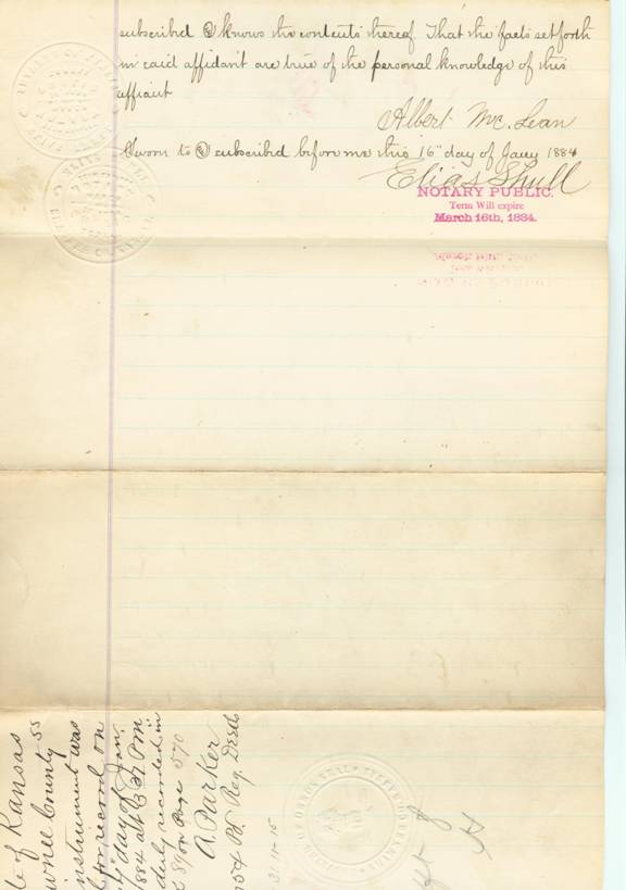
Figure 7 patent for
the land.
Language: The Potawatomi are
Algonquian speakers. Their language
family covers upper eastern North America. The language is closely related to Powhatan, Ojibwa
and Ottawa. They understand each other, like we
understand Cockney in England. The name of the Potawatomi tribe means
Keepers of the sacred fire in Ojibwa.
The Potawatomi call themselves Neshnabek (original people) in their
language.
The Osage are Siouan speakers. The Siouan language was Dhegiha spoken by the
Kansa, Omaha,
Ponca, Osage and Quapaw.
Dwellings: The Potawatomi lived in villages near rivers or
lakes. Their permanent villages were made
up of rectangular buildings of poles covered by cedar or elm bark. The buildings had a high arched roof. In the summer the living space for smaller
encampments was made up of oval, domed wigwams with saplings and covered with elm
bark or woven cattail mats. The holes in
the roof were made for the smoke to escape in both cases. Cooking shelters were separate. Menstruating women were isolated in smaller
structures also.
The Osage had permanent villages
for most of the year. Sometimes they
built lodges for their permanent villages.
The living space of the Osage was a wigwam covered with bark mats or
hides. The Osage lived in rectangular
bark covered wigwams. Small circular
lodges were less common. The Osage
hunting shelter was a tent with four poles in a rectangular pattern.
Subsistence: Potawatomi subsistence patterns depended on the season. They fished with hooks, lines, harpoons,
traps and weirs. They hunted beaver
raccoon, squirrel, opossum and elk or moose, bear and buffalo. Basically they hunted any game. Later the Potawatomi raised corn, peas, beans
pumpkins, squash and melons. Like many
Indians they grew tobacco for ceremonial purposes. The last buffalo hunt was legend. The Potawatomi were anticipating a long, cold
winter. Since buffalo were an important food source, preparations were made for
a hunt. The Potawatomi were good at curing and drying buffalo meat. They were skilled at making buffalo hides
into blankets. Federal regulations of
the 1840s required the Potawatomi to get permits from the Indian agent before
leaving the reservation. With a hunting permit the Potawatomi hunting party
traveled west in Kansas
to search for the buffalo. The partys horseback journey took them through
towns of Junction City, Lindsborg, Great Bend and Wakeeney,
before finally locating a buffalo herd. There, the Potawatomi hunting party
took enough buffalo to satisfy their needs.
This was their last hunt of the buffalo.
For the Osage, Hunting was the
primary subsistence activity but they did grow some corn, beans and squash and
dried and stored it. The Osage
farmed. Cattle had been provided by the
US Government in order to alter the Osage culture and it did not work. The Osage killed and ate livestock provided
by the US
government. Trade was critical to the
Osage. After European contact they
depended on the French for guns and metal objects. The Osage did what they could to keep the
Caddoans from trading with the French for guns. In the early 19th century the
Osage adopted European tools. (Volume 13
Plains p 478). Most Osage artifacts
found are from the French trading period.
They adapted to European tools quickly.
The Osage, in their migration, may have been exposed to the Oneota based
on early artifacts found in Osage sites. (Volume 13 Plains p 476)
Religion: The Potawatomi did
not have a structured religion early in history. The Potawatomi felt a part of all
creation. (Gale Volume 1: P258) They went on vision quests and had medicine
bundles. They did adopt religion later
like the Dream dance or drum cult.
They tried the peyote cult in later years. Their Christianity still has elements that
balance between nature and humanity. The
Potawatomi believed that there are two spirits who govern the world. One is called Kitchemonedo, the Great
Spirit and the other Matchemonedo, the Evil Spirit. The first is good and beneficent. In former times the Potawatomi worshiped the
sun, they sometimes offered sacrifice to the sun in order to cure the sick or in
order to obtain something. The Potawatomi would hold what was called the
"feast of dreams. Dog meat was used at this feast. Burial was probably underground, though there
is evidence that placing the body on a scaffold was practiced (Gale Volume 1:
P258).
Osage Controlling power was called
Wakanda. There were 24 paternal clans
and each had a life symbol sacred bundle.
The village plan followed their idea of the universe. The Osage lived in
a Moiety with Tsizhu (North) and Honga (South). One Moiety came to the earth from the sky. Osage kinship was of the Omaha Indian type. That is that the Mother and Mothers sister
were called mother. It also meant that
the Father and Fathers brothers were called father. The Osage participated in the Peyote
ritual. The Osage chief Black Dog (whose
namesake trail is famous for traversing the lower part of Kansas)
had a Peyote altar near Hominy, Oklahoma
(Volume 13 Plains: p480).
Political organization / Customs:
Potawatomi organization
centered on Clan membership. Each clan
has an origin myth and related to an animal.
They guard the sacred bundle.
Clan chants were all different.
Songs and dances bestowed names. Naming practices are very important to
the Potawatomi. This was like secret
societies.
Osage organization was built around
a Moiety. Each Moiety chief had equal
authority. Hereditary chiefs were
replaced with War chiefs. Warfare was
put under the Little Old Men who could recite the words Life cycle
polygamy. The post marital residence
moved from the fathers family to the mothers family (Volume 13 Plains p
478).
Treaties: The Potawatomi were originally located around the
southern portions of Lake Michigan, in southern Wisconsin,
northern Illinois
and northwestern Indiana. After removal of Indians from Michigan, Indiana, Illinois and Wisconsin,
most Potawatomi moves until they settled on the reservation in northeastern Kansas (figure 1). They like most Indians were moved west of the
Mississippi.
Some of the Potawatomi went to Southwestern Ontario.
(Kehoe, p 303) Following 1833, most of
the Potawatomi people were moved from the tribe's lands. Many died on the
trip to the new lands through Iowa, Kansas and Oklahoma.
Under the Indian Removal Act, the Potawatomi were
relocated west, to Missouri in the mid-1830s and then to Council Bluff, Iowa in the 1840s. After
1846, the tribe moved to Kansas
.
The reservation was thirty square miles which included part of present-day Topeka
(figure 1, 2, 3, 4 and 5). This is discussed
later in regard to the affidavit for land my Mothers Grandmothers family that
settled just west of
Topeka. It was called Indian Hill Farm. One can see it was on west Wannamaker road. The farms hill was flattened for development
about 12 years ago, but the hill was a source of Indian artifacts.
The Potawatomi tribe originated around the Great Lakes. The tribe was living off the resources of
the Great Lakes. Anything else they needed they acquired
through trade with other tribes. During
this time the Potawatomi held no real concept of land ownership. Their beliefs
taught them that land belonged to all living things. The U.S. Government, in
its first treaties with the Indians, established boundaries for tribal land. In
the treaties that followed the Potawatomi agreed to sell land to the
Government. Those concessions led to more loss of land.
The 1830 Removal Act was policy of the United States government. The
policy revolved around a dream that the Indian "problem" could be
eliminated by persuading the eastern Indians to exchange their lands for
territory west of the Mississippi.
The exchange would leave the area between the Appalachians and the Mississippi river free for white settlement.
During this migration west, the Potawatomi made stops in Platte Country Missouri
in the mid-1830s and Council Bluffs,
Iowa in the 1840s. The tribe
controlled millions of acres at both locations. After 1846 the tribe moved to
present-day Kansas, the "Great American
Desert." The area
lacked the resources of the Great Lakes, the political
reality of the removal left the tribe no choice. It amounted to a period of
adjustment for the tribe, just like so many times in the past. At that time,
the reservation was thirty square miles which included part of present-day Topeka.
Settlement changed with the passage of the Kansas-Nebraska Act of 1854. Opening
this territory to settlement started immigrating white settlers. The settlers
moved onto Indian lands. It was called
"squatter sovereignty." Additional white migration to Santa Fe and Oregon areas
made land like the Kansas
Territory suddenly very
appealing.
Two treaties cut the reservation into portions that accommodated individual
interests. The railroad received over 338,000 acres, Jesuit interests 320
acres, Baptist interests 320 acres, and the rest was divided into separate
plots. The Jesuits, failed to make Kansas a
center of Catholic activity around St. Mary's Mission.
Congress passed the Dawes Act (the General Allotment Act) of 1887. Congress
said they could no longer protect Indian lands from further settlement and the
demands of the railroads and other enterprises. The basic premise of the
General Allotment Act was to give each Indian a private plot of land on which
to become an industrious farmer. To hasten assimilation, the law provided for
the end of tribal relationships, such as land held in common. It stipulated
that reservations were to be surrendered and divided into family-sized farms of
160 acres for each male and smaller portions for other people which would be
allotted to each Indian. The aim was to substitute white culture for tribal
culture.
The Potawatomi refused to recognize their allotments of land or the right of
the government to make changes. The government withheld federal payments due
the Potawatomi Prairie Band and gave double allotments of the tribes land to
whites, Indians from other tribes, and the agent's relatives. Much of the allotted
land was too poor to farm, and the tribe received no financial credit and was
given little help of any kind.
The Osage began treaty-making with
the United States in 1808,
by the Osage Treaty and their first cession of
lands in Missouri. The1808 treaty also provided for approval by
the U.S. President for future land sales and cessions. In 1808 the Osage moved
from their homelands on the Osage River to western Missouri. Part of the tribe had moved to the
Three-Forks region of Oklahoma
soon after the arrival of the Lewis and Clark Expedition. The Civil war slowed settlers
interest in moving the Osage from reservations, but after the war those lands
were ceded.
Between the first treaty and 1825, the Osages ceded
their traditional land in Missouri, Arkansas, and Oklahoma
to the US
in the treaties of 1818 and 1825. They were to receive reservation lands and
supplies to help them farm and lose their native culture. They were first moved
onto a southeast Kansas reservation called the
Osage Diminished Reserve,
(Independence, Kansas). As stated earlier the first Osage reservation
was a 50 by 150-mile strip (figure 1). White squatters were a problem for the
Osage. Subsequent treaties and laws through the 1860s reduced the lands of the
Osage. By a treaty in 1865 they ceded more land and faced eventual removal from
Kansas to Indian
Territory.
The Drum Creek Treaty passed by Congress July 15,
1870 was ratified by the Osage in Montgomery
County, Kansas on
September 10, 1870. The treaty provided that the remainder of Osage land in Kansas be sold and used to relocate the Osage to Indian Territory. The Osage benefited by the change in Washington administration. The Osage sold their land to the
administration of President Grant. They
received $1.25 an acre rather than the 19 cents previously offered to them by
the US
and given to other tribes. The Osage
occupied land in present-day Kansas and in
Indian Territory which the US
government promised to the Cherokee and four other tribes. When the Cherokee
arrived to find that the land was already occupied, many conflicts arose with
the Osage over territory and resources (figure 1).
The Osage bought their own reservation, and they
retained rights to the tribes land and sovereignty as a result. Their reservation is Osage county Oklahoma in
the north-central portion of the state between Tulsa
and Ponca City. Life was hard on the Oklahoma
reservation as described in 1917 when Congress met to help with the relief of
the Osage in Oklahoma. Senator Charles Curtis from Kansas was part of that committee. The agent J George Wright had not even been
on the reservation and all of his activity favored oil and gas companies
developing the land. Part of the relief
was to provide money for the use of the resources (figure 12 and 13 showing parts
of the congressional record).
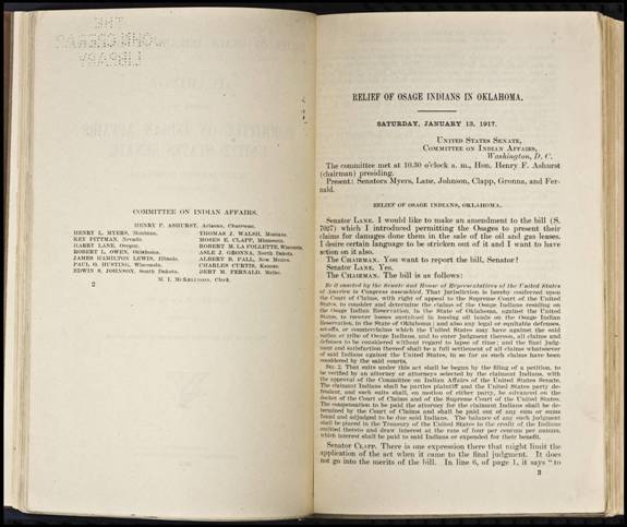
Figure 12
congressional record of Relief of the Osage Indians
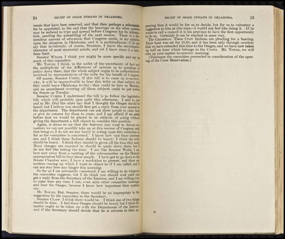
Figure 13 showing
Kansas Sen. Curtis was interested in relief of the Osage and there was pressure
to move on to the next tribe in 1917
Conclusion: The significance of this comparison is that the two
tribes spoke different language but shared a number of common traits in their
culture due to their similar life ways.
My Family
link to Tribal Land: Potawatomi On my mothers
side the Eddy family Property was transferred from an Addison Hughes. The
Potawatomi controlled millions of acres. After 1846, the tribe moved to Kansas. At that time,
the reservation was thirty square miles which included part of present-day Topeka (figure 1). Addison Hughes obtained land that was part of
the reservation from Joseph Negahnquet and his wife Nodnoque. It was defined as the NE quarter of section
number 31 in township number 11 south of range number Fifteen East Shawnee county Kansas by warranty deed
Oct 11, 1875 (figure 3, 4 and 5). Joseph
Nequahnquet moved to Indian Territory and he was killed shortly after his
arrival in Oklahoma.
This is in relation to the documents
for land my Mothers Mothers family settled just west of Topeka they called Indian Hill Farm that
was on west Wannamaker road. The farm
and hill was razed for development about 12 years ago, but was a source of
Indian artifacts for the family for years.
The Eddy
property on Potawatomie reservation was bought from a Negahnquet. Interestingly there was an Albert Negahnquet,
who was Potawatomi, the first full-blood Indian of the United States
to be ordained a Catholic priest. Born near St Marys, Kansas, in 1864, he moved with his parents
to the Potawatomi Reservation. (Pottawatomie
County, Oklahoma), From
that point Albert Negahnquet attended a Catholic mission school of the
Benedictine monks. Finally Negahnquet entered the College of the Propaganda
Fide in Rome,
and was ordained a priest in 1903. Quite
a change from Indian culture to Catholic priest.
Osage: The Conely (Conley) brothers migrated to Osage Indian trust
lands in 1877. This property described
in detail is in Sumner
County and my Great
Grandfathers part of it was on Slate Creek. (figures 8 through 10) The three brothers came from Jasper, Illinois but likely they lived in Boone County, Kentucky
in 1877 based on their fathers home at the time of his death which was 1877. Robert M Conely, got Osage Trust land as the South west quarter of
Section 25, Township 33, south of range 2 east,160 acres ,1 Dec 1874. Osage Trust Lands to John C. Conely, was a land grant of the north ½ of the
Northwest quarter and the southeast quarter of the Northeast quarter of Section
26, Township 33, south of Range 2 east, 120 acres, 2 July 1877 (Osage trust
Lands). My Great Grand Father, George Northcutt
Conely, land grant was Lots # 1and #2, and the northwest quarter of the
southeast quarter of Section 25, Township 33, south of range 2 east, 90 acres,
20, February 1877. (Osage Trust Lands) All the land was in Sumner
County, ValVerde Township.
All lands were purchased through the Wichita,
Kansas district land
office. Robert M .Conely came to Kansas
first. Robert came by way of Colorado. Georges Land
grant was before Johns. These farms were less than a mile apart. This gives
more credence that these were the sons of Greenville Connelly (the brothers
changed the spelling at some point). John is stated as having arrived in 1873.
At least we know they are all in Kansas
by the end of 1877. Benjamin is listed with Johns family in the 1880 census.
Thats four of the five sons of Greenville Conely. The three sons of George Northcutt
Conely (my great grandfather) were born in Sumner County. The twins, Oliver and Oscar and definitely
Ira Melvin were born in Sumner
County. Roberts land and
Georges land are in the same section. Georges land lay near the Arkansas River. Johns was in the next section west. John
moved to be on the River at Gueda Springs Kansas for his Ferryboat business crossing the Arkansas River. We also know in 1880, John is in Bolton Township
Cowley County.
This township is adjacent to the river. In 1884, Robert M Conely is buying lots
in Winfield. George is next located in Walnut
Township, Cowley
County and in 1895 he is in Windsor Township.,
Cowley County (Grand Summit). After selling his land George Northcutt Conely
(Conley) started working for the Santa Fe Railroad and moved to Grand Summit
Kansas which is on the rail road right of way west of Cambridge
Kansas on highway 160 and North on Ferguson Ranch Road
which crosses the railroad twice before getting to Grand Summit 1894 Windsor Township Cowley
County. This substantiates that my family migrated to
Kansas
and
found a home on Indian reservation land from county records research.
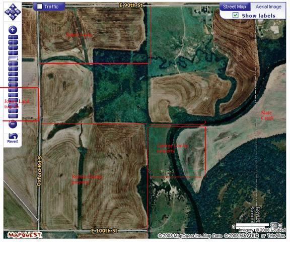
Figure 8: Conley Brothers
land from the Osage
Trust. My great grandfather seems to
have bought land with Slate Creek in the middle of it. Great bottom land but flooded. He sold it very quickly and moved to Grand
Summit Kansas.
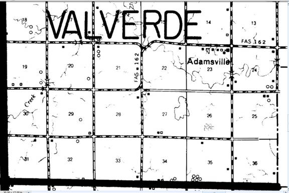
Figure 9 old county
map of the Conley
Land
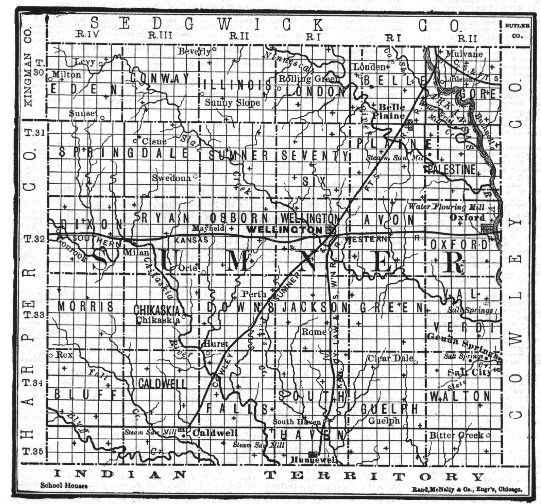
Figure 10: Old Map of the Osage Trust lands that were made
into available for purchase.
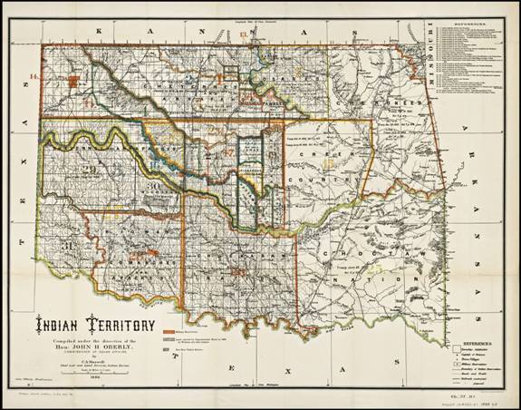
Figure 11 Indian Territory after the movement of the Osage and
Potawatomi
References:
Chapman, Butler J (1855) “Map of Kansas Territory” to
accompany his history of
Kansas
Bailey, Garrick A. (2001), “Osage”, Handbook of the
American Indian, Volume 13 the “Plains”. Volume 1, 476-496.
Kehoe, Alice B (2006), “North American Indians”, p 303
Malinowski,
Sharon
and Sheets, Anna editors (1998), “Potawatomi”, The Gale Encyclopedia of Native
American Tribes: Volume 1, 256-261
Young, Gloria A. (2001), “Intertribal Religious Movements”,
Handbook of North American Indians, Volume 13 the “Plains”, Volume 2, 996-1010
December 14, 2012