The Comanche Trail and the Jones and Plummer Trail
Through Blanco Canyon Texas
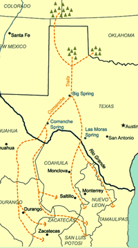
COMANCHE TRAIL. Though the Comanche Trail has long been named in the
historical literature of the Southwest, only an occasional reference is made
to it in contemporary records and documents. A map of West Texas made by J.
H. Young in 1857 shows such a trail. The lower portion had two prongs, one
crossing the Rio Grande about the vicinity of Boquillas and the other at Presidio.
The two converged at Comanche Springs, near the site of Fort Stockton. From
this point the trail extended north to cross the Pecos at or near Horsehead
Crossingqv and continued northeasterly across the sand hills to the site of
present Big Spring. From Big Spring it extended east of the Caprockqv past
watering spots on Tobacco Creek, Mooar's Draw, and Gholson Spring. From this
point there were two routes across the Staked Plains. One was up Yellow House
Canyon by Buffalo Spring to the forks of the canyon in what is now Mackenzie
State Recreation Areaqv in Lubbock, thence up the north fork of the Double
Mountain Fork of the Brazos, where there was running water just west of the
site of present Abernathy. From there this branch extended to Sod House Spring,
north of the site of present Littlefield. From this point it ascended Blackwater
Draw to Portales Spring, to Tiban Spring, and thence to the Pecos near Fort
Sumner. The alternative route from Gholson Spring extended southeast to Blanco
Canyon and thence up that canyon and Running Water Draw, past the site of
present Plainview about twenty miles, at which point the route left the draw
and extended west to Spring Lake. From there it continued to Blackwater Draw,
where it intercepted the Yellow House route fifteen miles east of the site
of present Muleshoe. Young's map indicated that water could be had daily from
Big Spring northward and northwest to the site of Fort Sumner, New Mexico.
The upper portion of the trail from Plainview westward was possibly used by
Francisco Vásquez de Coronadoqv on his return to the Pecos.
BIBLIOGRAPHY: Joe Cunningham, "The Comanche Trail," Texas Parade,
December 1952. Edward N. Todd, "The Comanche Trail," Frontier Times,
July 1974.
JONES AND PLUMMER TRAIL. The Jones and Plummer Trail
was established in the fall of 1874, when two former buffaloqv hunters turned
merchants and freighters, Charles Edward (Dirty Face) Jones and Joseph H.
Plummer,qqv established a store at the head of Wolf Creek. They had seen the
need for a convenient place for buffalo hunters to sell hides and obtain supplies
after Quanah Parker'sqv raid had convinced the Dodge City merchants to abandon
the Adobe Walls trading post. Jones marked the trail, and the partners' trips
to and from Dodge City to deliver hides and buffalo meat and to purchase goods
cut ruts into the sod deep enough for others to follow. From Dodge City the
trail angled southwest, paralleling Crooked Creek, to cross it and the Cimarron
River near the Oklahoma-Kansas line. From there it continued on to Beaver,
Oklahoma. At Beaver the Dodge City Trail (see WESTERN TRAIL) branched off
to the southwest. The Jones and Plummer Trail continued due south for thirty
miles to the site where Booker now stands. Passing Brubaker Lake, it headed
southwest toward Gillalow Lake and on to the Jones and Plummer store on Wolf
Creek just east of what is now U.S. Highway 83. The route to this point covered
about 160 miles. The trail was extended farther south to Mobeetie but kept
its original name. Mobeetie grew rapidly, making the trail attractive to additional
freighters. Mose Hayes, an early plainsman, described the lower half of the
trail thus: "more freighting came down the Jones and Plummer Trail about
Clear Creek and turned off to the east before it got to the end of the [original]
Jones and Plummer Trail on Wolf and continued south across Wolf Creek...and
crossed the Canadian, and then up Red Deer, out on the plains, and on to Mobeetie."
Freighters were not the only users of the trail. During the late 1870s Jones
and Plummer's store gained a reputation as a safe place for outlaws to hide
and replenish their supplies. In the winter of 1878 Bartholomew (Bat) Mastersonqv
and a posse from Dodge City pursued a gang of train robbers along the trail,
only to lose them at the store.
During the peak freight years of 1880 to 1886 the Jones and Plummer trail
provided a crucial conduit for the materials needed to sustain such important
projects as the building of Fort Elliott. Troops in the field, hunters, ranchers,
homesteaders, and towns also depended on the goods that passed along the Jones
and Plummer Trail. At times, the sheer volume of freight was remarkable. For
example, a single merchant, Charles Rath,qv shipped 150,000 pounds of freight
a week to Mobeetie in 1878. Eventually five towns were established along the
trail, which served as their primary artery for commerce and travel. After
1879 the trail was used by mail contractors, and in 1886 P. G. Reynolds made
it a major stagecoach route from Dodge City to Mobeetie. Though primarily
a freighting trail, the Jones and Plummer Trail was also used by cattlemen
driving herds north. The trail's usefulness ended when rail lines were built
into the region, making the wagon trade uneconomical. Pulling into Panhandle
City on January 1, 1888, an Atchison, Topeka and Santa Fe locomotive rang
its bell, signaling the end of yet another frontier trail. The Rock Island
line extended service to southwestern Kansas in the same month. Thus, by the
last decade of the nineteenth century, the Jones and Plummer trail had ceased
to be a major factor in the growth of a region embracing parts of three states.
BIBLIOGRAPHY: C. Robert Haywood, Trails South: The Wagon-Road
Economy in the Dodge City-Panhandle Region (Norman: University of Oklahoma
Press, 1986).
C. Robert Haywood